Plans for Invasion
As Admiral King has written, "Because of the urgency of seizing and occupying Guadalcanal, planning was not up to the usual thorough standard."1 Admirals Nimitz and Ghormley had begun planning in June, but the planes and men which were to make the attack were scattered from the South Pacific to California.
General MacArthur's and Admiral Ghormley's assertion that there were few troops available for beginning the attack was well founded. Besides the three divisions in Australia and the elements of the 1st Marine Division in New Zealand, there were several units in the South Pacific assigned to the defense of bases along the line of communications. Two Army divisions were in the area; the 37th Division was in the Fijis, the Americal Division in New Caledonia. The 7th Marines, a regiment detached from the 1st Marine Division, was in Samoa. Army infantry and artillery units were at Bora Bora; the 147th Infantry, formerly of the 37th Division, was at Tongatabu. Some Army, Navy, and Marine Corps troops were holding Efate in the New Hebrides and part of the Efate force was building an airfield at Espiritu Santo in the New Hebrides.
The majority of the Army troops in the South Pacific had been dispatched prior to the establishment of the South Pacific Area; they had been administered directly by the War Department and supplied directly by the San Francisco Port of Embarkation. The organization of the South Pacific Area, the commitment of more Army Air Forces units, and the imminence of the forthcoming campaign led the War Department to organize these forces into a single commandthe U. S. Army Forces in the South Pacific Area (USAFISPA). On 14 July Maj. Gen. Millard F. Harmon was appointed its commanding general (COMGENSOPAC) with the concurrence of the Navy.2
1. Admiral E. J. King, Our Navy at War: A Report to
the Secretary of the Navy Covering Our Peacetime Navy and Our Wartime Navy
and including Combat Operations up to March, 1944 (U.S. News, March
1944), p.34.
2. History of the United States Army Forces in the South
Pacific Area during World War II: 30 March 1942-1 August 1944 (4 vols.),
Pt. I, I, Ch. I, passim. Hereafter cited as Hist USAFISPA. A copy
of the manuscript is filed in the Hist Div, SSUSA.
Prior to his appointment as Commanding General of U. S. Army Forces in the South Pacific, Harmon, who was one of the senior officers of the Army Air Forces and a pioneer in military aviation, had been Chief of the Air Staff. Born in 1888, he was graduated from the U. S. Military Academy in 1912, and entered the Aviation Section of the Army Signal Corps while in the Philippines. After active service in France during World War I, he attended the Army Command and General Staff School and the Army War College, taught Military science and tactics at the University of Washington in Seattle, and served with various training and tactical air units until the end of 1940. In January 1941 he was sent to Britain as an air observer. Returning to the United States four months later, he was made a major general in July and in January 1942 he became Chief of the Air Staff.
General Harmon, under Ghormley's command, was to be responsible for the administration and supply of Army units in the South Pacific. His letter of appointment directed him to advise the Area Commander, but gave him no operational or tactical authority. On 26 July he assumed his duties, with headquarters first at Auckland and later, adjacent to Ghormley's, at Noumea, New
Caledonia. His services proved so valuable that both Admiral Ghormley and his successor consulted him in the planning and execution of the Guadalcanal and subsequent South Pacific campaigns.
Despite the fact that there were about 32,000 Army ground troops in the South Pacific,3 they could not be freely used for reinforcement of the marines in the attack against Guadalcanal. There was not enough shipping space in the South Pacific for free movement, and the divisions holding the Fijis and New Caledonia could not be moved until replacements were available, or until the Japanese offensive threat had been eliminated.4
Little was then known about the objective. The Solomons are a thinly populated and undeveloped area. Lying about 800 miles east of New Guinea, the Solomons form a double chain of tropical, mountainous islands extending from latitude 5 degrees South to latitude 12 degrees 30 minutes South, from northwest to southeast, and from longitude 155 degrees East to longitude 170 degrees East. They include several hundred islands, with a land area of 18,670 square miles. The largest in the northeastern chain are Buka, Bougainville, Choiseul, Santa Isabel, and Malaita. The southwestern islands consist of the Shortland, Treasury, and New Georgia groups, the Russells, Guadalcanal, Florida, San Cristobal, and Rennell.
The Solomon Islands chain was divided politically. Bougainville and Buka were part of the Australian Mandated Territory of New Guinea. The rest of the islands formed the British Solomon Islands Protectorate. A British district officer, responsible to the Resident Commissioner at Tulagi, administered civil affairs on each island in the protectorate. The Resident Commissioner reported to the High Commissioner for the Western Pacific in the Fijis, who in turn was responsible to the Colonial Office in London. Economic development had been slight. Lever Brothers, with local headquarters at Gavutu, had been operating fairly extensive coconut plantations since before the war, and the Burns-Philp South Seas Company, Ltd., controlled island shipping. The few white residents before the war were government officials, planters, missionaries, and their families. Some, including the Resident Commissioner and several district officers, missionaries, and nuns, had remained in the Solomons during the Japanese occupation. The government officials, like the coastwatchers, had withdrawn to the hills. The missionaries and nuns, with some exceptions, had not been molested, but had continued to operate their stations under surveillance.
3. Ibid., Pt. III, I, 441.
4. COMSOPAC to CINCPAC, 0414 of 13 July 42. SOPAC War
Diary.
The native inhabitants are Melanesians of primitive culture. Noted in former years for their ferocity, they remained generally loyal to the Allied cause and throughout the Solomons campaign assisted the coastwatchers, rescued fliers and sailors, and acted as guides, scouts, and laborers.5
The Solomons are one of the world's wettest areas. Rainfall in some places exceeds 200 inches per year; from 1922 to 1942, annual rainfall at Tulagi averaged 164 inches.6 The tropical temperatures are enervating, ranging daily from 73 to 93 degrees Fahrenheit at sea level. Humidity is high. There are only two seasons, the wet and the dry. Northwest monsoons bring almost daily rain during the wet season from November to March. The term dry is relative, for southeast trade winds bring frequent rains during the dry season.
There are few good harbors, but the narrow, restricted channels between the islands are usually calm. In the southern Solomons the best anchorage is Tulagi Harbor between Tulagi and Florida Islands. Tulagi, Gavutu, and Tanambogo Island, near Gavutu in Tulagi Harbor, all possessed some docks, jetties, and machine shops. There are few clear, flat areas suitable for airfields except on Malaita, Bougainville, New Georgia, and the grassy plain on Guadalcanal's north coast. (Map IV)
Between Guadalcanal and Malaita lies the smaller island of Florida (Nggela), which is separated from Guadalcanal by Sealark Channel. Reefs jut above the water to make the channel north of the center of Guadalcanal very narrow. The waters between the southern reefs and Guadalcanal are called Lengo Channel; those between the northern reefs and Florida are Nggela Channel.7 Between the southeast part of Guadalcanal and Malaita is Indispensable Strait, and at the northern end of Sealark Channel, between Guadalcanal and Florida, lies the small symmetrical island of Savo.
Admiral Nimitz' Plan
By late June Admiral Nimitz had decided to send five Marine air squadrons to the South Pacific to take part in the campaign. Airfield construction
5. See (British) Central Office of Information, Among
Those Present: The Official Story of the Pacific Islands at War (London,
1946).
6. R. W. Robson (ed.), The Pacific Islands Year Book,
(4th ed., Sydney, 1942), p. 131.
7. For simplicity, Sealark Channel will be used throughout
this volume to refer to all the waters between Tulagi and Guadalcanal.
in the South Pacific was, therefore, to be given a high priority.8 As the five squadrons, all consisting of short-range aircraft, would have to be ferried across the Pacific on an aircraft carrier, the pilots would first have to train for carrier operations.9 Following Admiral Nimitz' request that more Army bombers be sent to the South Pacific, General Marshall authorized the creation of two Mobile Air Forces for the Pacific Theaterone in the Southwest Pacific Area and one in the Pacific Ocean Areas. Each was composed of one B-17 heavy bombardment group.10 The Pacific Ocean Areas Mobile Air Force might be used anywhere within the Pacific Ocean Areas at the Joint Chiefs' discretion. The 11th Heavy Bombardment Group, then in Hawaii, was selected as the Pacific Ocean Areas Mobile Air Force on 16 July, and within four days its four squadrons had taken off for New Caledonia.11
To provide more troops for the landings, Admiral King had suggested that the reinforced 2d Marines (of the 2d Marine Division), then in California, be shipped to the South Pacific immediately; Admiral Ghormley agreed, and he requested that the 2d Marines be combat-loaded and ready for landing operations on arrival.12 Admiral Nimitz ordered the 2d Marines to be ready to sail from San Diego aboard five ships on 1 July.13 Admiral Nimitz also decided to send the 3d (Marine) Defense Battalion from Pearl Harbor to the South Pacific to provide antiaircraft and seacoast defense of the target areas. Three aircraft carriers, one battleship, and accompanying cruisers and destroyers would be available to constitute the naval supporting forces to which would be added warships from the Southwest Pacific Area.
Admiral Nimitz issued his final plan for the attack on 8 July. He ordered the South Pacific Force, under Admiral Ghormley, to capture the Santa Cruz Islands and the Tulagi-Guadalcanal area in the Solomons. As the Joint Chiefs had planned, marines were to capture the areas. Army forces, under Admiral Ghormley's direction, would then relieve the marines. Naval forces would support these operations and construct and operate the air bases for both land-based planes and seaplanes, and Army aircraft were to operate from the bases as di-
8. CINCPAC to COMINCH, 0251 of 27 Jun 42. SOPAC War Diary.
9. Disp, CINCPAC to COMINCH, 2251 of 27 Jun 42. OPD 381
SWPA Sec. 11 Case 80.
10. Rad, WDCSA to CINC SWPA, CM-OUT-2222, 3 Jul 42.
11. ACofS for Intelligence, Air Staff, Hist Div, AAF
Hist Studies No. 35: Guadalcanal and the Origins of the Thirteenth Air
Force, p. 2.
12. COMINCH to CINCPAC, 1415 of 27 Jun 42; COMSOPAC to
CINCPAC, 0607 of 28 June 42. SOPAC War Diary.
13. 2301 of 27 Jun 42 (no addressee). SOPAC War Diary.
rected. A seaplane base, providing for thirty planes, was to be built at Tulagi. Air bases, each large enough to support four air squadrons, were to be built both at Guadalcanal and at Ndeni in the Santa Cruz Islands. The Navy was to be responsible for maintaining radio stations, harbor facilities, inshore patrol, port control, hospitals, underwater defenses, and roads and bridges at the bases. A 6o-day level of subsistence supplies and ammunition and a go-day supply of building materials were to be maintained. The Navy was to furnish materials for the construction of airfields, bases, and harbors.14
Admiral Ghormley's Plan
The problems facing the South Pacific commanders in preparing for the invasion were tremendous, and time was short. Admiral Ghormley, acting on the first orders from Admiral King before the issuance of the Joint Chiefs' directive and Admiral Nimitz' final plan, had called the commanding general of the 1st Marine Division from Wellington to his headquarters at Auckland on 26 June. The 1st Division commander and part of his staff began conferring with Admiral Ghormley on that date, and were joined the next day by Rear Adm. john S. McCain, the commander of all Allied land-based aircraft in the South Pacific (COMAIRSOPAC).15 Not all the commanders who were to take part in the operation were present. Vice Adm. Frank J. Fletcher and Rear Adm. Richmond K. Turner, who were to command the Expeditionary and Amphibious Forces, had not then reached the South Pacific. Admiral Ghormley informed the Marine officers of the plan to invade the Solomon and Santa Cruz Islands, and ordered them to prepare plans and load ships in Wellington for the invasion. Detailed planning in the South Pacific had thus been initiated prior to the issuance of the directive on 2 July; the directive did not necessitate any basic changes in Ghormley's or the marines' concepts of the operation.
Admiral Ghormley issued his Operation Plan No. 1-42 on 16 July 1942. It was to govern the execution of Task One which was to be divided into three phases. The first would be a rehearsal in the Fiji Islands; the second would be the seizure and occupation of Tulagi and Guadalcanal. The projected occupation of Ndeni in the Santa Cruz Islands would be the third and final phase.
Operation Plan No. 1-42 organized two forces, Task Forces 61 and 63. The Expeditionary Force of eighty-two ships (designated as Task Force 61), was
14. CINCPAC, File A4-3/FF 12/A 16 (6) Ser 01994, Basic
Supporting Plan for Advanced Air Bases at Santa Cruz Island and Tulagi-Guadalcanal,
8 Jul 42, in Plans and Opns Div, GSUSA.
15. Rear Adm. Aubrey W. Fitch replaced McCain as COMAIRSOPAC
on 21 September 1942.
placed under the command of Admiral Fletcher. The main body of warships of Task Force 61 came from the Pacific and Atlantic Fleets, while a second came from the naval forces of the Southwest Pacific. The third component assigned to Task Force 61 was the amphibious force, which included the marines who were to make the landings. Admiral Turner was to assume command of the South Pacific Amphibious Force on 18 July.16 The second force, Task Force 63, consisted of all the Allied land-based aircraft in the South Pacific under Admiral McCain.
Analyzing the strength and capabilities of the enemy forces which Task Forces 61 and 63 were to attack, Admiral Ghormley anticipated that the Japa-
16. Commander, Amphibious Force, South Pacific Force, Pacific Fleet (TF62), War Diary, Aug 42-30 Sep 42, 18 Jul 42. A copy of this diary, hereafter cited as COMAMPIUBFORSOPAC War Diary, is in the Office of Naval Records and Library.
nese garrisons in the Solomons and Bismarcks might soon be reinforced. The Japanese could shuttle their aircraft between the Marshall Islands, New Britain, and the East Indies. Elements of the 4th Fleet had already been operating in the vicinity of the Solomons and Bismarcks, and the addition of a submarine division might be expected. Rabaul was known to be a major air base, and seaplane bases were known to be in use at Gizo, Rekata Bay, Faisi, Kieta, Buka, and Gavutu. Two planes had been based at Tulagi, thirteen at Gavutu. The runway under construction at Lunga Point was not thought to have been completed.
Ghormley estimated that about 3400 Japanese troops were in the Tulagi-Guadalcanal area. He believed that, of these, one thousand Special Naval Landing Forces and pioneers were stationed on Guadalcanal at Cape Esperance, the Segilau River, Lunga Point, Tenaru, and Taivu Point on the north coast. It was assumed that there were at least six antiaircraft guns at both Lunga Point and Kukum, with more at Taivu Point to the east. Ghormley considered, correctly, that the south coast was not held in any strength.
After assembling and rehearsing in the Fijis, the Expeditionary Force (Task Force 61) was to capture and occupy Tulagi and near-by areas, including that part of Guadalcanal most suitable for the construction of airfields. The tentative date for D Day set by the joint Chiefs of Staff1 Augustcould not be met. On 16 July Ghormley notified Admiral Nimitz that the late arrival of the 1st Marine Division's second echelon at Wellington, New Zealand, coupled with the delay in loading caused by bad weather in Wellington, would necessitate postponing the target date until 7 August.17 The date could not be postponed further, however, lest the Japanese complete their airstrip for use against the Allied forces.18
Once Tulagi and the landing field on Guadalcanal had been taken, the Expeditionary Force would occupy Ndeni, and troops were to be ready to work on airfields on Guadalcanal and Ndeni immediately. Airfield construction materiel and troops would be sent forward as soon as possible. To free the Amphibious Force for further offensive action, occupation troops were to be dispatched to relieve the marines. Operation Plan No. 1-42 did not specifically designate the forces to effect the relief and occupation but stated that orders would be issued at a later date.
The land-based aircraft of Task Force 63 were to support and cover the
17. COMSOPAC to CINCPAC, 0612 of 16 Jul 42. SOPAC War
Diary.
18. COMINCH to COMSOPAC, 1830 of 28 Jul 42. SOPAC War
Diary.
movements of the Expeditionary Force, arrange special missions at the request of Task Force 61, and carry out their regular scouting missions. Task Force 63 was to cover the Amphibious Force's approach to Tulagi and Guadalcanal and the landing there, as well as to execute air attacks by arrangement with Task Force 61. Amphibious patrol bombers were to patrol temporarily from Ndeni, which had not been occupied by the Japanese, by D minus 1, and additional patrol planes would scout from the east coast of Malaita on D plus 1.19 After the conclusion of the Guadalcanal phase, Task Force 63 would cover the occupation of Ndeni by the landing force.
Admiral Ghormley, announcing his intention to proceed from Auckland to Noumea aboard his flagship Argonne about D minus 5, stated that he would arrange a conference between representatives of the commanders of the Expeditionary and Amphibious Forces and of the South Pacific land-based aircraft to settle the final details of air support and to co-ordinate the various air efforts. The commander of Task Force 63 was also ordered to arrange for air scouting by Southwest Pacific Air Forces.
Logistical plans for the operation took into account the lack of good bases in the South Pacific Area. During the rehearsal, all vessels were to take on fuel as the tactical situation permitted from tankers at Noumea and the Fijis, and from tanks on shore in the Fijis and Espiritu Santo and Efate in the New Hebrides. Fleet units were to take on full loads of ammunition after the rehearsal. Only minor ship repairs could be effected in the South Pacific. Auckland had a dockyard and a drydock, and a floating drydock at Wellington could accommodate a heavy cruiser. In addition the repair ship Whitney was stationed at Tongatabu, and a salvage tug was to be stationed initially at Espiritu Santo. For major repairs, heavy fleet units would have to go to Pearl Harbor.
Fleet units would carry sufficient provisions to be self-sustaining, while the Amphibious Force would embark sixty days' supply and ten units of fire for the marines. Fresh foods would be supplied to the Amphibious Force if enough ships were available.
Once they were unloaded, ships of the Amphibious Force were to leave the Solomon and Santa Cruz Islands and return to Noumea unless directed elsewhere, and would be escorted by warships assigned by Admiral Fletcher. Returning ships would carry American wounded to the hospital ship Solace at
19. COMSOPAC to COMAIRSOPAC, 1300 of 20 Jul 42 in SOPAC War Diary, altered the plan. The original had been D minus 2 for Ndeni and D Day for Malaita.
Noumea, which would either retain the wounded on board or distribute them among the Army hospitals at Noumea and the Fijis, or take them to the naval base hospital at Auckland.20
Admiral McCain's Plan
Toward the end of July, when Admiral McCain's tactical plan for Task Force 63 was completed, South Pacific air strength had increased and the air bases had been improved. Two companies of the 182d Infantry and one engineer company of the Americal Division had occupied Efate in the New Hebrides on 18 March to build an airfield. Marine Corps and naval personnel followed these forces, until by May there were 7,500 on the island. On 28 May 500 men of the Efate garrison had occupied Espiritu Santo, 145 miles to the north. Admiral Ghormley had ordered the construction of a bomber strip on Espiritu Santo, to be completed by 28 July, in time to support the invasion of the Solomons.21 B-17's of the 11th Heavy Bombardment Group arrived in the area during July. The 98th Squadron landed in New Caledonia on 22 July, followed by the 42d the next day. The 431st Squadron landed in the Fijis on 24 July, and the 26th landed at Efate on 25 July.22
By the end of July Task Force 63 consisted of 291 aircraft of various types, based on New Caledonia, the Fijis, Tongatabu, Samoa, and Efate, and assigned to the defense of those islands. Of the 291 planes, 31 Navy patrol bombers (PBY's) were based on New Caledonia and the Fijis. Ninety-three naval fighters were based on Efate, New Caledonia, the Fijis, Tongatabu, and Samoa. Twenty-five naval observation planes were operating from Efate, New Caledonia, Tongatabu, and Samoa, and seventeen Navy scout bombers (SBD's) were based in Samoa.
Ninety-five Army planes were in Task Force 63. Thirty-five Army B-17's and twenty-two B-26's were stationed at New Caledonia and the Fijis. Thirty-eight Army P-400's [sic] were also operating from New Caledonia. Nine Vincents, eighteen Hudsons, and three Singapores of the Royal New Zealand Air Force were based on New Caledonia and the Fijis.23
20. COMSOPAC, Opn Plan No. 1-42, A4-3/A 16-3, Ser 0017,
16 Jul 42. Copy No. 120 of Operation Plan 1-42 is in the Office of Naval
Records and Library. Code names assigned were as follows: Task One, PESTILENCE;
rehearsal, DOVETAIL; Guadalcanal-Tulagi invasion, WATCHTOWER; Ndeni occupation,
HUDDLE. The code name of Guadalcanal was CACTUS; that of Tulagi, RINGBOLT.
21. COMSOPAC to COMAIRSOPAC, 2314 of 2 Jul 42; COMSOPAC
to CG Efate, 2538 of 5 Jul 42, SOPAC War Diary.
22. 11th Bomb Gp (H), Hist, P. 4, in Archives, AF Hist
Off.
23. COMAIRSOPAC, Opn Plan No. 1-42, A4-3/A16-3, Ser 0016,
25 Jul 42. A photostatic copy of this plan is in the Office of Naval Records
and Library.
Admiral McCain issued his orders on 25 July. He divided Task Force 63 into seven task groups. One group, consisting of the 69th (Army) Bombardment Squadron, the 67th (Army) Fighter Squadron, a New Zealand Air Force Hudson Squadron, and two PBY's, was to scout over 400-mile sectors from New Caledonia. A second group, consisting of the 11th (Army) Heavy Bombardment Group, to be based on New Caledonia, Efate, Espiritu Santo, and the Fijis, was to scout between New Caledonia and the Solomons and over and west of the Solomons. It was this group which carried out bombing attacks on Guadalcanal and Tulagi prior to D Day. The third group, consisting of the seaplane tender Curtiss and attached patrol planes, was to move part of its patrol planes to Espiritu Santo. Beginning on D minus 2 the planes based in Espiritu Santo were to search both east and west of the Solomons, while the remaining patrol planes moved from Noumea to Ndeni and Espiritu Santo. The fourth group, composed of the seaplane tender MacFarland and attached patrol bombers, was to move to Ndeni to inaugurate the air searches northeast of the Solomons on D minus 1. The fifth, composed of the seaplane tender Mackinac and attached patrol planes, was to proceed to the east coast of Malaita on D minus 3. The sixth group, consisting of Marine Fighting Squadron 212 and Scouting Squadron D-14, was to send three scouts to Espiritu Santo, and to aid the bombardment effort from Efate. The final group, consisting of Marine Observation Squadron 251, was to assist the bombardment effort from Espiritu Santo.
The air searches of Task Force 63 would thus cover the general area between New Caledonia and the Solomons, over the Solomons, east to Ndeni, and south to the Fijis. General MacArthur agreed to have Southwest Pacific air forces patrol the northern and western approaches to the Solomons during Task One. Prior to D minus 5, Southwest Pacific air forces were to reconnoiter over eastern New Guinea, Lorengau, Kavieng, Buka, Ontong Java, and Tulagi. Thereafter no Southwest Pacific planes were to fly east of longitude 158 degrees 15 minutes East (a line just west of Guadalcanal and east of New Georgia, Choiseul, and Bougainville, in the Solomons group), and latitude 15 degrees South unless requested by Ghormley. From D minus 5 to D Plus 4, Southwest Pacific aircraft were to conduct daily reconnaissance flights over eastern New Guinea, Kavieng, and the easternmost point of New Georgia, and combat aircraft were to be ready to strike any Japanese naval vessels within a 550-mile radius of Port Moresby. From D Day to D Plus 4, when the transports and cargo ships-of the Amphibious Force would be unloading at Guadalcanal
and Tulagi, Allied aircraft would thus be interdicting Japanese aerial operations in the Rabaul-Kavieng area. At the same time Buka was to be attacked to prevent the Japanese from refueling there. During this critical period, short-range aircraft were to attack Lae and Salamaua periodically to prevent those bases from sending aircraft to reinforce Rabaul.24
Admiral Fletcher's Plan
The Expeditionary Force Commander, Admiral Fletcher, issued his Operation Order No. 1-42 to Task Force 61 on 28 July. Task Force 61 was divided into two groups, the Air Support Force and the Amphibious Force. The Air Support Force, under the command of Rear Adm. Leigh Noyes, consisted of twenty-six warships and five tankers. This group was subdivided into three units, each built around an aircraft carrier. The first included the Saratoga, two heavy cruisers, and five destroyers. The carrier Enterprise, the battleship North Carolina, one heavy cruiser, one light antiaircraft cruiser, and five destroyers constituted another unit. The third unit was composed of the carrier Wasp, two heavy cruisers, six destroyers, and five tankers.25
The Amphibious Force, under the command of Admiral Turner, consisted of twenty-three transports and twenty-eight warships. Turner's force was composed of the South Pacific Amphibious Force, the naval forces from the Southwest Pacific, and three heavy cruisers, one light antiaircraft cruiser, and six destroyers from the Central Pacific.
The Amphibious Force was to sail from the Fijis to a point about 400 nautical miles south of the west tip of Guadalcanal, and then to sail north at 12 knots toward the objectives. This course would keep the force well away from Japanese-held islands until time for the assault.
As the Amphibious Force would be landing its troops on islands which lay beyond range of fighter planes from the nearest Allied bases, it was to receive tactical air support directly from the Air Support Force which would also execute necessary aerial reconnaissance. It was apparently Fletcher's intention to withdraw the carriers prior to D Plus 3, somewhat short of the time required for the Amphibious Force to unload its ships completely. Admiral Ghormley was aware of this intention. Emphasizing the need for continuous air cover over the target area, he stated that if the airfield at Guadalcanal was operational he intended to base there squadrons from the carriers. These squadrons
24. COMSOWESPAC (CINC SWPA) to COMSOPAC, 1034 of 19 Jul
42. SOPAC War Diary.
25. See also ONI, USN, Combat Narratives: Solomon Islands
Campaign, I, The Landing in the Solomons, 7-8 August 1942 (Washington,
1943).
would then be relieved by land-based fighters sent in from Efate with extra gasoline tanks.26 But Admiral McCain pointed out that ten days would be required to fit the extra tanks to the Navy F4F fighters.27
The advancing Amphibious Force was to be further protected by submarines operating in the vicinity of major Japanese bases. Five submarines of the Pacific Fleet were to cover the Truk area from 22 July to 20 August, while submarines from the Southwest Pacific were to patrol the waters near Rabaul.28
Admiral Ghormley's plan provided that, on the withdrawal of the Air Support Force, the Amphibious Force was to secure air support from Task Force 63. It should be noted, however, that the distances separating Espiritu Santo and Efate from Guadalcanal would prevent Task Force 63 from providing fighter cover for the marines on Guadalcanal until the airfield there could be developed enough to serve as a base. The Amphibious Force was to furnish escorts for its transports returning to Noumea after unloading. Damaged ships were authorized to return either to Noumea or to put in to other convenient friendly ports.29
Admiral Turner's Plan
Like General Harmon, the officer assigned to command the Amphibious Force, Rear Adm. Richmond K. Turner, was also an aviator, but he had taken up flying at a comparatively late date. In 1908 when Turner was graduated from the U. S. Naval Academy as a passed midshipman, he held fifth place in a class of 201. Commissioned an ensign in 1910, he studied naval ordnance and engineering in the years prior to World War I. During the war he was a gunnery officer aboard several battleships, and in 1925 and 1926 he was on duty with the Navy Bureau of Ordnance. He completed naval aviation pilot training at Pensacola in August 1927, and commanded air squadrons for nearly two years. From 1929 to 1931 he served in the Plans Division of the Bureau of Aeronautics, and in 1932 he was a technical adviser to the United States delegation at the General Disarmament Conference at Geneva. He then served aboard the carrier Saratoga, and after graduation from the Naval War College in 1936 he served on the
26. COMSOPAC to CTF 61, 0240 of 2 Aug 42. SOPAC War Diary.
27. COMAIRSOPAC to COMSOPAC, 1436 of 4 Aug 42. SOPAC
War Diary.
28. COMSOPAC Opn Plan No. 1-42.
29. CTF 61, Opn Ord No. 1-42, Opn WATCHTOWER, Ser 0032
N, 28 Jul 42. A photostatic copy of this order is in the Office of Naval
Records and Library. The numerical designations assigned to the component
units may be confusing. What had been task forces of the Pacific Fleet
became task units of one group of TF 61. The amphibious force, made up
of two task forces, was given a task group number.
staff there for two years. In 1939 he commanded the cruiser Astoria when she carried the remains of Ambassador Hirosi Saito to Japan. In 1940 Turner became Director of the War Plans Division of the Office of the Chief of Naval Operations, and in early 1942, a change in the organization of the Office of Naval Operations gave him the title of Assistant Chief of Staff to the Commander in Chief of the U. S. Fleet. He held that post, which was also concerned with war plans, until he was ordered to the Pacific in the summer of 1942, at the age of fifty-seven.
Admiral Turner, who after conferring with Admiral Nimitz at Pearl Harbor had reached Wellington on 15 July, issued Operation Plan No. A3-42 to the Amphibious Force on 30 July. He divided his force into eight groups: Transport Group X, Transport Group Y, the Guadalcanal Fire Support Group, the Tulagi Fire Support Group, the Minesweeper Group, the Screening Group, the Air Support Group, and the Landing Force Group, which consisted of the 1st Marine Division, Reinforced (less the 7th Marines).
Transport Group X, assigned to the Guadalcanal landing, consisted of four transport divisions. Two of the divisions were each composed of three transports and one cargo ship; the third, of two transports and one cargo ship; and the fourth, of one transport and three cargo ships. Transport Group Y, assigned to the landings in the Tulagi area, consisted of two transport divisionsone made up of four transports and the other of four destroyers previously converted to troop carriers (APD's). Four more ships, the Zeilin and the Betelgeuse and their escorting destroyers, were to transport the 3d Defense Battalion from Pearl Harbor.
The Guadalcanal Fire Support Group consisted of three fire sections composed of one heavy cruiser and two observation planes each, and of two fire sections of two destroyers each. The Tulagi Fire Support Group consisted of one light antiaircraft cruiser and two destroyers. There were five minesweepers in the Minesweeping Group.
The Amphibious Force's second-in-command, Rear Adm. V. A. C. Crutchley, R.N., commanded the Screening Group. It consisted of three Australian cruisers, one U. S. heavy cruiser, nine destroyers, two fighter squadrons based on the aircraft carriers, but detached to the Screening Group on D Day, and eight observation seaplanes from the cruisers. The Air Support Group was made up of one fighter and one dive bomber squadron, plus one additional fighter and one additional dive bomber squadron for the initial mission, all drawn from the carriers.
The Landing Force was led by the commanding general of the 1st Marine Division. It was divided into two groupsthe Guadalcanal Group directly under the division commander, and the Northern Group under the assistant division commander. Six observation planes from the cruisers Astoria and Quincy were assigned to the Guadalcanal Group, and two planes from the cruiser Vincennes were assigned to the Northern Group.
Admiral Turner, in his analysis of enemy strength against which the Amphibious Force would have to contend, estimated that at least 150 Japanese planes were based in the Bismarck-New Guinea area, and that 11 Japanese cruisers, 13 destroyers, 15 submarines, 12 patrol bombers, 15 or 17 transports, and a number of motor torpedo boats were available. The Amphibious Force was to expect attacks by the planes based at fields from Rabaul to Salamaua. Admiral Turner warned his force that submarines, motor torpedo boats, cruisers, destroyers, and transports might be met around Tulagi. The Guadalcanal-Tulagi garrison was estimated to total 7,125, a figure more than double Ghormley's. It was believed that 1,850 men constituted Tulagi's garrison, whose armament included antiaircraft and coast defense guns, seaplanes, and picket boats. The rest of the troops were supposed to be in the Lunga area on Guadalcanal, which was protected by antiaircraft and coast defense guns.
The Amphibious Force was to assume attack dispositions on D minus 1 and to arrive in the transport areas off Guadalcanal and Tulagi before sunrise of D Day. The main landings were to be made on the center of the south coast of Tulagi, and on a 1,600-yard-long sandy beach between the Tenaru and Tenavatu Rivers on the north coast of Guadalcanal, about 6,000 yards east of Lunga Point. H Hour, the time of the Tulagi landing, was set for 0800 for planning purposes. Zero Hour, the time of the Guadalcanal landing, was originally set for 0830. Admiral Turner's flagship, the cargo ship McCawley, was the site of the 1st Marine Division's floating command post. Admiral Crutchley flew his flag aboard the Australia.
The majority of the Amphibious ForceTransport Group X, the Guadalcanal Fire Support Group, one fighter squadron and one dive bomber squadron, and about two regimental combat teams of the 1st Marine. Divisionwas assigned to the assault on Guadalcanal. Transport Group Y, the Tulagi Fire Support Group, one fighter squadron, one dive bomber squadron, and the balance of the Marine division, except the reserve, were assigned to the northern attack.
Air attacks by the planes directly supporting the Amphibious Force were to inaugurate operations on D Day. Communication and control between the
Amphibious Force and the air squadrons were to be effected through an air support director group from the carrier force stationed aboard the McCawley. An alternate director group was to be aboard the Neville.
Fifteen minutes before sunrise of D Day, while the transports were approaching their unloading areas, one fighter squadron was to destroy any aircraft at Lunga or Koli Points on Guadalcanal, and any seaplanes, motor torpedo boats, or submarines operating near the island's north coast. At the same time a second fighter squadron would strike similar targets near Tulagi. Two dive bomber squadrons, assisted by the fighters, were to hit antiaircraft and coast defense guns on Guadalcanal, Tulagi, and Gavutu. Dive bombers were also to cover the assaulting landing craft as they moved toward the beaches. Beginning one hour after sunrise on D Day, fighters and dive bombers were to maintain stations overhead to protect the transports.
Admiral Turner ordered the fire support warships to fire at all antiaircraft and coast defense guns, to cover the minesweepers, and to be on the alert against torpedo boats and submarines. Warships were to take care to avoid interfering with landing craft formations, and for the safety of the American troops were to use percussion instead of time fuzes against shore targets. The warships were to provide naval gunfire liaison teams, equipped with radios, to go ashore with the troops.
The naval gunfire support problem in the Tulagi area was more complicated than that for Guadalcanal. Numerous near-by islets and promontories of Florida Island lie within artillery and even small-arms range of Tulagi. The ships' gunfire plan called for supporting fires to be placed, prior to the landings, on all the islets as well as on parts of Florida and on Tulagi. The ships were also to put fire on the radio station on the southeastern part of Tulagi, and on Tulagi's antiaircraft positions. Starting at H Plus 30 minutes the party on shore was to designate targets. The Tulagi Fire Support Group and the air squadrons were also to bombard the southeast portion of Tulagi when the troops, advancing southeast from the landing beach, had reached the first phase line, about two-thirds of the way down the island. The signal from the troops for this bombardment would be a green star cluster flare.
The cruisers of the Guadalcanal Fire Support Group were to cover the area between Lunga and Koli Points with fire starting at daylight of D Day. The four destroyers were to take stations at Zero minus 30 minutes to serve as control and salvage vessels by the landing beach; they were to mark the line of departure for the initial boat waves 5,000 yards north of the beach. All ships of the
group were to close in by Zero minus 10 minutes to give direct support to the landing. From Zero minus 1o to Zero minus 5 minutes, they were to put fire to a depth of 200 yards on an area extending 800 yards on either side of the beach, using 1135 8-inch and 1,400 5-inch rounds. Starting at Zero Plus 5 minutes, the ships were to put fire ashore to assist the advance of the combat teams from the landing beach west to the Lunga airfield.
The liaison planes assigned to the landing forces were to mark the flanks of the beaches with smoke at H minus 20 and Zero minus 20 minutes, respectively. Starting at H plus 1 hour, one plane was to assume station over Guadalcanal for observation duty for the field artillery. If ground-to-air radio communication failed, communications between the ground forces and the liaison planes were to be maintained by message drops and ground panel codes.
Transport Groups X and Y were to land the troops, equipment, and supplies of the 1st Marine Division on Tulagi and Guadalcanal in accordance with that division's plans. The destroyer-transports of Group X would act as control and salvage vessels for the boats landing at Tulagi.
The minesweepers were to sweep the shallows south of Tulagi from H to H plus 11 hours. Three minesweepers were then to sweep the waters from the Guadalcanal landing beach east to Taivu Point, while two cleared the area off the beach itself. The Transport Group commanders were authorized to move their ships in close to the landing beaches once the waters were proved safe. On D plus 1, the minesweepers would clear the Kukum Beach area just west of Lunga Point.
The Screening Group would guard the Amphibious Force against surface, air, and submarine attacks. One fighter squadron was to cover the transport areas during daylight while the ships were unloading. Control would be exercised through a fighter director group from the carrier forces aboard the Chicago. During enemy air attacks the fire support warships would come under Admiral Crutchley's control to screen the transports with antiaircraft fire, and, in the event of surface attack, would also support the Screening Group. On the completion of their shore fire missions the fire support warships were to pass to Admiral Crutchley's command. During the amphibious phase, one observation plane from the Vincennes was to conduct antisubmarine patrols, reporting results to the Screening Group.
Admiral Turner intended to establish Amphibious Force headquarters ashore once the objectives had been captured and the amphibious phase ended. Communications with the area commander would be maintained through the
1st Marine Division's radio. A small naval force, including a boat repair section, boat crews, and twelve LCM's (landing craft, mechanized), twenty LCP(L)'s (landing craft, personnel) and thirty LCV's (landing craft, vehicle), was to be established at Guadalcanal and Tulagi.
It was estimated that the transports would be unloaded and could withdraw from the forward area by the night of D plus 1. They were to retire under the command of Rear Adm. Norman Scott, the commander of the Tulagi Fire Support Group. The cargo ships were to be unloaded by D Plus 4, and were to retire under command of Admiral Crutchley.
The force for the Santa Cruz operation, consisting of one cruiser, four destroyers, four transports, one cargo ship, and the 2d Marines, Reinforced, having formed an integral part of the Amphibious Force for the Guadalcanal-Tulagi invasion, was to depart from the Guadalcanal area about D Day to occupy and defend Ndeni.
On completion of the entire operation the air squadrons were to revert to Task Force 61. The Amphibious Force organized for the invasions was to be dissolved on orders from Admiral Fletcher, but the South Pacific Amphibious Force proper would remain in existence.30
The 1st Marine Division, which was to make the landings, had been moving overseas while the Joint Chiefs of Staff were discussing the attack against the Solomons. Brought to war strength at New River, N.C., between 7 December 1941 and 1 May 1942, it had then been organized around two infantry regiments, the 1st Marines and 5th Marines, and one artillery regiment, the 11th Marines. The 7th Marines, the third infantry regiment, had been detached for service with the 1st Provisional Marine Brigade in Samoa. The division had engaged in field exercises and combat firing at New River, and during March and April each battalion landing team of the 5th Marines and one of the 1st Marines engaged in 10-day landing exercises at Solomon's Island, Md.
The division was commanded by a 55-year-old veteran of Caribbean and Chinese expeditions, Maj. Gen. Alexander A. Vandegrift. After attending the University of Virginia for two years, Vandegrift had been commissioned a 2d lieutenant in the Marine Corps in 1909. He served in Nicaragua, Mexico, and
30. CTF 62, Opn Plan No. A3-42, Opn WATCHTOWER, Ser 0010, 30 Jul 42. A copy of this plan is in the Office of Naval Records and Library. Admirals Fletcher and Turner, who prepared their plans separately, used different numbers to designate the amphibious force. Fletcher used 61.2, Turner, 62.
Haiti, and in 1916 began two years' service with the Haitian Constabulary. After a brief tour of duty in the United States, he served again in Haiti from 1919 to 1923. Upon completing the Field Officers' Course at Quantico, Va., in 1926, he became Assistant Chief of Staff at the Marine Base at San Diego, Calif. Vandegrift then served for over a year as Operations and Training Officer on the staff of the 3d Marine Brigade in China. Returning to the United States in 1928, he held various staff positions, including one with the newly-founded Fleet Marine Force, until 1935. He served in Peiping, China, for two years, and from 1937 to 1941 was at Marine Corps Headquarters in Washington. Ordered to the 1st Marine Division in 1941 as a brigadier general, he was promoted to major general and took command of the division in March 1942 with Brig. Gen. William H. Rupertus as his assistant division commander.
Vandegrift had not believed that his division was sufficiently well trained for combat when he was notified in April that it was to be sent to New Zealand as part of the South Pacific Amphibious Force to establish bases and train for "minor landing offensives and counter-attacks to be designated at a later date".31 He had not expected that any combat missions would be assigned before January 1943.32 Division headquarters and the 5th Marines reached Wellington, the capital city of New Zealand, on 14 June, but the second echelon did not arrive until 11 July.
The second echelon was still at sea when Admiral Ghormley called Vandegrift to Auckland on 26 June to announce the plan to use the 1st Marine Division (less 7th Marines), reinforced by the 2d Marines, the 1st Raider Battalion, and the 3d Defense Battalion, in the Solomons about 1 August 1942. The division's plans had to be prepared semi-independently, for Admirals Fletcher and Turner had not yet arrived in the South Pacific. According to Vandegrift, "there was no time for a deliberate planning phase, and in many instances irrevocable decisions had to be made even before the essential features of the naval plan of operations could be ascertained"; there was "an absence of meeting of minds of commanders concerned." General Vandegrift's plans were based upon the assumption that the Allies would firmly control the air and sea routes to the Solomons.33
31. COMINCH, F F 1/A3-1/A16-3(5) Basic Supporting Plan
for the Establishment of the SOPAC AMPHFOR (Lone Wolf Plan), Ser 00322,
29 Apr 42. Copies of this plan are in Plans and Opns Div, GSUSA.
32. 1st Mar Div, Final Rpt Guadalcanal Opn, I, 2. Copy
in the files of the Hist Div, SSUSA.
33. Ltr, CG 1st Mar Div to Comdt Mar Corps, 1 Jul 43,
sub: Final Rpt Guadalcanal Opn, in 1st Mar Div Rpt, V.
In a little over one month the division, hiding its preparations under the guise of preliminaries for amphibious training, had to prepare tactical and logistical plans, unload part of its ships, reload for combat, sail from Wellington to the Fijis, rehearse, and sail to the Solomons, in addition to gathering data on the islands and on Japanese strength and dispositions there.
Terrain and Intelligence
The 1st Marine Division's intelligence section, on receiving. Ghormley's orders, immediately began to gather data on terrain, landing beaches, climate, and the natives, from U. S. Army and Navy monographs, extracts from the Pacific Islands Year Book, and reports of the British Navy and Colonial Office. There was no opportunity for ground patrols to reconnoiter the islands prior to the invasion. Col. Frank B. Goettge, the intelligence officer of the 1st Marine Division, and his section interviewed former Solomons residents, civil servants, and merchant ships' officers in New Zealand. On 1 July Colonel Goettge flew to General MacArthur's headquarters to collect information. Spending one week in Melbourne and several days in Sydney, he interviewed former residents of the Solomons in those cities. Eight of these men were given commissions or warrants by the Australian forces and were attached to the 1st Marine Division as guides, advisers, and pilots. They reported to division headquarters on 15 July to interpret maps and aerial photographs.
The Solomons, with their green mountains, forested shores, low-hanging clouds, and coral reefs, are beautiful when viewed from the air or from the calm interisland channels, but they present difficult terrain for military operations. They are covered by heavy, tropical rain forests. Mountains, deep rivers, swamps, heat, humidity, heavy rains, and mud, combined with the jungle, make all movements extremely difficult. Except along the sandy beaches vehicles cannot move until roads have been built. At the opening of the campaign there were few vehicular roads. Tulagi had some trails, and a trail had been built through the coconut groves on the north coast of Guadalcanal, but the only inland passages were native footpaths. There were no bridges suitable for artillery and heavy equipment.
The islands are unhealthful; malaria as well as dengue fever is common. The malarial (Anopheles) mosquito breeds in swamps, lagoons, sluggish streams, and puddles, and has seeded the natives heavily. In addition, fungus infections and sores were to plague all the troops. Only the utmost efforts at the prevention of disease would keep troops healthy, but living and combat conditions on Guadalcanal were to make systematic malaria control difficult.
Guadalcanal, which is shaped like a Paramecium, is ninety miles long and averages over twenty-five miles in width. A backbone of forested mountains and quiescent volcanoes, rising in some places as high as 7,000 feet, runs the length of the island. Coral reefs and sharply rising mountains make the south coast inhospitable for ships. The north coast has no harbors, but Sealark Channel is calm. Many sandy beaches on the north coast are free of reefs and provide suitable landing areas for amphibious operations. From Aola Bay to the Matanikau River, between the mountains and Sealark Channel, there is a flat, narrow, grassy plain. Coconut plantations line most of the beach, and there are some stretches of high, tough kunai grass. The plain is cut by many rivers and streams. They are generally deep and swift, and are frequently flooded by rains. Stagnant pools have formed at most of the river mouths through the accumulation of silt which, massing cones and sand bars, blocks the flow of water.
The coastal plain ends east of the Matanikau River; between the river and Cape Esperance at the northwest tip of the island a narrow corridor lies between the coastline and the high ground on the south. Steep ravines and abruptly rising ridges cut laterally across the corridor. Lunga Point, where the Japanese were building their airstrip in July and August of 1942, is dominated by Mount Austen, a 1,514-foot-high series of ridges and knolls about six miles southwest of the point.
Colonel Goettge returned from General MacArthur's headquarters with its intelligence estimate of enemy strength and dispositions in the Solomon Islands, New Guinea, and the Bismarck Archipelago. This estimate, supplemented by aerial reconnaissance and reports from coastwatchers, was the basis of the division's estimate of enemy strength and dispositions in the Solomons. On 20 July division headquarters believed that 8,400 Japanese were on Guadalcanal and Tulagi, a figure which, like Admiral Turner's, much exceeded Admiral Ghormley's.34 However, by 30 July, Admiral Turner had reduced the Marines' estimate to 7,125
The 1st Marine Division continued to receive radio reports from the coastwatchers, which were monitored and transmitted by the American radio at Efate, even after the division's departure from Wellington. During the week preceding D Day, the Solomons coastwatching net broadcast reports three times daily in a special code. The reports were to have been relayed directly from Efate to Admiral Turner's flagship at sea, but as the code had not been
34. 1st Mar Div Opn Ord No. 7-42, 20 Jul 42, Annex A, included in CTF 62, Opn Plan No. A3-42 as App. D.
properly intercepted they had to be relayed through Australia and New Zealand, a process which sometimes delayed them for three days.35
On 17 July two officers of the Marine division were taken by a B-17 on a reconnaissance flight from Port Moresby over Guadalcanal and Tulagi. They saw no evidence of any airfields, except for burned-off areas at Lunga Point and Tetere, nor any extensive beach defenses on the north coast of Guadalcanal. Returning to Wellington by way of Townsville, Australia, they brought back aerial photographs of Tulagi and a strip map of the Guadalcanal coast between Koli Point and the Matanikau River.
There were no good maps of Guadalcanal, a deficiency that was, in fact, never remedied throughout the campaign. During the planning phase the division's intelligence section never received what it considered an adequate number of aerial photographs of Guadalcanal, although it received a large number of the Tulagi area. The intelligence section used two U.S. Navy Hydrographic Charts as the bases for its maps. Chart No. 2658 of Tulagi and Gavutu, on a scale of 1/12,000, was fair, showing approximate elevations. Chart No. 2916 of Guadalcanal and Florida was enlarged to a scale of 1/108,643 but was inaccurate and lacked recent corrections. A crude sketch which had been prepared by colonial officials before the war aided in locating some trails and buildings but lacked contour lines and elevations. The division's base map for the Guadalcanal landing was a 9-sheet strip drawn and reproduced by the photolithographic section from aerial photographs which Colonel Goettge had brought from Australia. The map, based on photographs taken in late June, covered a narrow coastal strip on Guadalcanal from Lunga Point east to Aola. A rough, uncontrolled sketch showing rivers, plains, plantations, and forests, it was reproduced before the Amphibious Force's sortie from Wellington. No more photographs reached the division until 2 August, when Admiral McCain forwarded photographs which had been taken by a B-17 and had been developed aboard the Enterprise. These pictures of Tulagi and Lunga Point showed that the airstrip was nearly complete.
Logistics
The problems of logistics proved as serious as had those of procuring information about enemy strength and dispositions. Preparations began before the intelligence section had completed its work and before the final tactical plans were prepared. The logistical plans were based upon General Vandegrift's or-
35. 1st Mar Div Rpt, I, Int Annex E.
ganization of the division for combat. On 29 June he organized the division into two regimental combat groups each of about 4,500 men. Each group was organized into a headquarters and support group and three battalion combat teams.36 Every combat group consisted of one infantry regiment, one artillery battalion, one company each from the tank, engineer, pioneer, amphibian tractor, and medical battalions, and scout, special weapons, and transport platoons. Each combat team was originally composed of one infantry battalion, one field artillery battery, and platoons of engineer, pioneer, and amphibian tractor personnel. Scouts, signal, medical, and other service personnel were added to the combat teams prior to the invasion.
Combat Group A, commanded by Col. Le Roy P. Hunt, was composed of the 5th Marines and supporting troops. Combat Teams Nos. 1, 2, and 3 of Combat Group A consisted of the reinforced 1st, 2d, and 3d Battalions, respectively, of the 5th Marines. Combat Group B, Col. Clifton B. Cates commanding, was made up of the 1st Marines and supporting troops. Combat Teams Nos. 4, 5, and 6 of Combat Group B consisted of the reinforced 1st, 2d, and 3d Battalions, respectively, of the 1st Marines. On 9 July the division support group was organized.37 It consisted of about 3,500 men under Col. Pedro A. del Valle organized into four subgroups made up of headquarters, communications, medical, artillery, special weapons, pioneer, engineer, and amphibian tractor personnel and the 1st Parachute Battalion. The parachutists, fighting as infantry, were later assigned to the assault on Gavutu. The rear echelon, 1,729 men from all divisional units, including the 4th Battalion, 11th Marines (155-mm. howitzers), was to remain in Wellington when the division departed.
As each combat group was to be embarked in a transport division consisting of three transports and one cargo ship, every transport in each division was assigned to carry one combat team, three units of fire, thirty days' rations, and quartermaster, ordnance, engineer, chemical, signal, and medical supplies. Supporting troops, heavy equipment, seven units of fire, thirty days' rations and other supplies, and clothing stocks were assigned to each cargo ship.38
The logistical difficulties did not stem from shortages of materiel, for the division had come overseas with nearly all its equipment and supplies. The
36. 1st Mar Div Opn Ord No. 5-42, 29 Jun 42, in 1st Mar
Div Rpt, I, Annex B. The terms in the operation order differ from present
day usage. The combat groups would now be regimental combat teams. The
combat teams would be battalion landing teams.
37. 1st Mar Div Opn Ord No. 6-42, 9 Jul 42, in 1st Mar
Div Rpt, I, Annex D.
38. Airmailgram, CG 1st Mar Div to CO, Combat Gp A, 29
Jun 42, in 1st Mar Div Rpt, I, Annex C.
shortages were in dock space, time, and shipping. In late June there were just seven ships of the Amphibious Force in Wellington Harbor-five transports and two cargo ships.39 More vessels had been assigned, but it was apparent that there would not be enough cargo space to combat-load all the division with its supplies and equipment. To embark the maximum number of troops, General Vandegrift ordered that "all units ... reduce their equipment and supplies to those items that are actually required to live and fight."40 The division was ordered to embark bulk supplies, including rations and fuel, for sixty days instead of the ninety days then considered necessary.41 The ammunition allowance was reduced by one-half. Office equipment, cut to a minimum, included no more than two typewriters per battalion headquarters and four per regimental headquarters. Mess equipment was limited to water bags, vacuum food carriers, camp kettles, coffee mills, and stoves. The order directed that all the division's motor transport would be embarked; all sandbags, rubber boats, outboard motors, camouflage and chemical warfare equipment, all engineering materiel,42 water purification equipment, sixty days' clothing replenishment (shoes, socks, and green utility suits), and thirty days' post exchange supplies (tobacco, matches, soap, and razor blades only) were to be embarked. Officers and enlisted men were ordered to take with them all their individual equipment but to reduce their baggage to a minimum. Each officer was allowed one bedding roll, clothing roll, or handbag, while enlisted men were limited to what they could carry in their packs.
Loading the division's weapons and supplies on board the ships was a difficult matter. Aotea Quay in Wellington was small and could berth only five ships at the same time. Combat Group A had already landed, unloaded, and been established inland in base camps prior to 29 June. To clear the quay for the second echelon, it was decided, to begin the embarkation of Combat Group A and its equipment and supplies on 2 July. The division supply officer organized the embarkation and combat loading, exercising control through transport quartermasters on the ships and through field officers in charge of the 300-man working parties assigned to each ship. Organized into three reliefs, the working parties labored around the clock in 8-hour shifts. Except for a few skilled
39. SOPAC War Diary, 19 Jun 42.
40. 1st Mar Div Admin Ord No. 1a-42, 29 Jun 42, in 1st
Mar Div Rpt, I, Annex J.
41. 1st Mar Div Rpt, I, 6; Ltr, CG 1st Mar Div to Comdt
Mar Corps, 1 Jul 43, sub: Final Rpt Guadalcanal Opn.
42. The first orders stated that the temporary pier would
not be loaded. They were apparently changed, for the engineers brought
the pier to Guadalcanal. No subsequent orders regarding the pier are in
1st Mar Div Rpt, I.
civilian operators of loading machines, cranes, hoists, carriers, and stacking machines, marines performed all dockside labor. All divisional motor transport plus eighteen 10-wheeled trucks of the 1st Base Depot and thirty flat-bedded New Zealand Army lorries moved supplies, equipment, and ammunition from their depots to the dockside. By 13 July Combat Group A and its gear had been embarked. A few shortages were made up by local purchases in Wellington, and others were alleviated by materiel carried by the second echelon. After embarkation Combat Group A practiced landings in Wellington Harbor.
The second echelonlargely troops of Combat Group B and the Support Groupencountered much greater difficulty. It arrived at Aotea Quay on 11 July, while Combat Group A was completing its embarkation. As it had not been anticipated that the division would be tactically employed after its arrival in New Zealand, the ships had not been combat-loaded before leaving the United States. Most of the troops had been carried across the Pacific aboard passenger vessels, while cargo ships carried their supplies and equipment. The second echelon was forced to unload, sort, and classify stores and equipment on the limited dock space, and to reload for combat by 22 July. The weather had been clear while the first group had embarked, but, during the entire period of the second echelon's unloading and reembarkation, cold, driving rains typical of a New Zealand winter made the task miserable. The morale of the troops, working in the rain, was low.43 Many of the supplies had been packed in cardboard cartons, which, becoming soggy from the rains, burst and strewed their contents over the docks. Other cardboard cartons, stacked inside the warehouse, were crushed.
Lack of cargo space prevented the division from loading all its motor transport aboard the twelve available ships. Nearly all the quarter-ton and one-ton trucks were put aboard, but 75 percent of the heavier vehicles were left behind in Wellington with the rear echelon. The engineers expected that the Lunga Point airfield would perhaps be almost complete by D Day, but put earth-moving equipment, in addition to bridging equipment and a portable dock, aboard the cargo ship Fomalhaut.
Medical preparations for the campaign had not been difficult. Those medically unfit for foreign service had been left behind in the United States. The standard of health remained fairly high, except for troops on board one transport of the second echelon. Among those marines rotten food on the voyage to
43. 1st Mar Div Rpt, I, Logistics Annex L.
New Zealand had caused a loss of weight varying from sixteen to twenty pounds per man, as well as a diarrhea epidemic. Exposure while loading in Wellington had resulted in some cases of colds and influenza, and a few sporadic cases of mumps broke out en route to the target area. The medical plans provided for medical care, under combat conditions, of 18,134 men for ninety days.44
By 22 July reloading had been completed, and the division was ready to sail from Wellington.
Tactical Plans
On 20 July, when logistical preparations had been almost completed in Wellington, General Vandegrift issued tactical orders for the landings. The grouping of forces for Tulagi and Guadalcanal was based upon the premise that of the 8,400 Japanese which the intelligence section believed to be defending the objectives 1,400 troops, including one infantry and one antiaircraft battalion, were in the Tulagi area. One reinforced infantry regiment, one antiaircraft battalion, one engineer battalion, pioneers, and others7,000 in allwere thought to be on Guadalcanal.45 The major part of these were expected to be at Lunga Point, with a smaller force at Koli Point. These estimates greatly exaggerated enemy strength. In early August there were about 780 Japanese in the Tulagi-Gavutu-Tanambogo area, and 2,230 on Guadalcanal.46 Admiral Ghormley's original estimate Of 3,100 had been correct.
As it was anticipated that the invasion of the Tulagi area, involving direct assaults against small islands, would be the most difficult, the most experienced battalions were assigned to this attack. To protect the flanks of the units landing on Tulagi and other islets, small forces were to land first on near-by Florida. One battalion would then land on Tulagi, followed quickly by a second. A third battalion would land on Gavutu at H Plus 4 hours to seize Gavutu and Tanambogo.
The Guadalcanal landing presented a simpler tactical problem than did the landing on Tulagi. The large number of undefended beaches on the north coast would make it possible for the remainder of the division to land unopposed at Some distance from the Japanese. The area selected for the landing lies between
44. 1st Mar Div Rpt, I, Med Annex M does not mention malaria.
45. 1st Mar Div Opn Ord No. 7-42, Annex A.
46. AFPAC G-3 Hist Sec, and ATIS, interrog of Lt Gen
Harukichi Hyakutake (former CG, 17th Army), Maj Gen Shuicho Miyazaki
(former CofS, 17th Army), and Lt Gen Masao Maruyama (former CG,
2d Div), 31 Aug 46; 17th Army Opns, I, gives even
lower figures1,850 on Guadalcanal, 1 company on Tulagi, and 1 platoon
on Gavutu.
the Tenaru47 and Tenavatu Rivers, about 6,000 yards east of the Lunga airstrip, well away from both Lunga and Koli Points. Having landed and established a beachhead, the Guadalcanal Group of the division under General Vandegrift could then attack west to capture the airfield. This maneuver would require the troops to cross both the Tenaru and the Ilu Rivers, but the Tenaru and the Tenavatu Rivers, on either flank of the beach, would help to protect the beachhead if the Japanese counterattacked while men and supplies were coming ashore.
The orders issued on 20 July utilized the previous organization of the division into combat groups, combat teams, and the support group. The orders also organized the reinforcing unitsthe reinforced 2d Marines, the 1st Raider Battalion, and 3d Defense Battalionwhich had not then joined the division. The
47. In the early maps, the names of the Tenaru and the Ilu Rivers were transposed. The Ilu lies about 2H miles cast of the Lunga. The wide part of the river is also known as Alligator Creek.
2d Marines, Reinforced, commanded by Col. John M. Arthur, included the 2d Marines, the 3d Battalion of the 10th Marines (75-mm. pack howitzers), and engineer, pioneer, amphibian tractor, tank, medical, and other service troopsa total of 4,840 men. This reinforced regiment was organized like the others into a headquarters and support group and three combat teams of about 1,300 each. Combat Teams A, B, and C were composed of the reinforced 1st, 2d, and 3d Battalions, respectively. The 1st Raider Battalion, totaling 828 men, was commanded by Lt. Col. Merritt A. Edson. The 3d Defense Battalion, Col. Robert H. Pepper commanding, totaled 872 men. These reinforcements, when they arrived, increased the division strength to over 19,000.48
The 20 July orders prescribed eight groups of varying strengths: Combat Group A, Colonel Hunt commanding, 4,398 (to be subsequently reduced by about 1,100 by the assignment of Combat Team No. 2, one reinforced infantry battalion, to the Tulagi attack); Combat Group B, Colonel Cates commanding, 4,531; the Support Group, Colonel del Valle commanding, 3,537; the Tulagi Group (the 1st Raider Battalion and Combat Team No. 2 of Combat Group A), Colonel Edson commanding; the Gavutu Group, Maj. Robert Williams commanding, 395 of the 1st Parachute Battalion; the Florida Group, Maj. Robert E. Hill commanding, 1,295 of Combat Team A (1st Battalion, 2d Marines, Reinforced); the 3d Defense Battalion; and the Division Reservethe 2d Marines, Reinforced, (less Combat Team A)Colonel Arthur commanding, 3,545.
These forces were to attack and destroy the hostile garrisons on Guadalcanal, Tulagi, Gavutu, Tanambogo, and Makambo by landings on D Day, and then to organize the defense of those islands. There were not enough landing craft, however, to execute all landings simultaneously. At H minus 20 minutes, one rifle company and one machine gun platoon of Combat Team A (1st Battalion, 2d Marines, Reinforced) were to land at Haleta on Florida, just west of Tulagi, to cover the Tulagi landing. At H Plus 30 minutes the remainder of Combat Team A would seize Halavo, the peninsula on Florida just east of Gavutu, and support the Gavutu assault by fire.
The Tulagi Group, led by the 1st Raider Battalion, would land on a 500-yard front on Tulagi at H Hour and seize the northwest part of the island. Having reached the first phase line about 1,500 yards northwest of the southeast shore, the assault troops would signal for a 5-minute air and naval bombard-
48. 1st Mar Div Rpt, I, 9, gives 19,546; Annex K gives 19,105; V, Personnel Annex W, gives 19,360 effectives.
ment upon the defense positions in the hills and ravines around Government House, the cricket field, the hospital, the prison, and the radio station, then attack and capture that area. Once taken, the island was to pass to the control of the commander of Combat Team No. 2 (2d Battalion, 5th Marines, Reinforced, less E Battery, 11th Marines) of Combat Group A. The 1st Raider Battalion would then prepare to re-embark for further operations. Combat Team No. 2 was to embark enough troops to seize Makambo, northeast of Tulagi, and also was to relieve the 1st Parachute Battalion after it had captured Gavutu and Tanambogo. The 3d Defense Battalion was to land one-third of its antiaircraft strength on Tulagi.
The 1st Parachute Battalion was to land on the east coast of Gavutu at H Plus 4 hours, seize it, and then take Tanambogo, the small island connected with Gavutu by a concrete causeway. The firing of a green star cluster would be the signal for five minutes of naval gunfire on Tanambogo from the Tulagi Fire Support Group. After the capture of the islets the battalion was to be prepared to re-embark for employment elsewhere.
While operations were being conducted against the northern islets by air squadrons, the Tulagi Fire Support Group, Transport Group, Y, and the Marine units under General Rupertus' command, the rest of the force-air squadrons, the Guadalcanal Fire Support Group, Transport Group X, and the majority of the Marine division under General Vandegrift-would be operating against Guadalcanal. Combat Group A (5th Marines, Reinforced), less Combat Team No. 2 (2d Battalion, Reinforced, less E Battery, 11th Marines), was to land at Zero Hour on a 1,600-yard front with combat teams abreast to take the beachhead. Combat Group B (1st Marines, Reinforced) was to land in column of battalions at Zero plus 50 minutes, pass through Group A, and attack westward toward the "grassy knoll" (Mount Austen) which was erroneously believed to be only four instead of six miles southwest of Lunga Point. This course, it was hoped, would prevent the Japanese from escaping southward into the mountains. The 1st Marines was to maintain contact with the units advancing on its right. The formation would be a column of battalions echeloned to the left and rear to protect the left flank. Group A, after Group B had passed through, was to send Combat Team No. 1 (1st Battalion, 5th Marines) west along the shore to seize the Ilu River line. In the order the Ilu was mistakenly called the Tenaru. Combat Team No. 3 (3d Battalion, 5th Marines) was to seize the line of woods running southeast from the Tenavatu River, thus covering the east line of the beachhead. The division's light tanks, landing with the combat groups, were
also to cover the east flank of the beachhead but were not to be committed to action except on orders from General Vandegrift. Platoons of A Battery of the 1st Special Weapons Battalion were to land on the flanks of the beach to provide antiaircraft defense with automatic weapons. They were to revert to control of the 1st Special Weapons Battalion of the Support Group upon the landing of that battalion's headquarters.
The artillery battalions of the combat groups were to land with their groups, but to pass to control of the headquarters of the 11th Marines of the Support Group upon the landing of that headquarters. The Support Group, including elements of the artillery, engineer, special weapons, and pioneer battalions was to land on orders from division headquarters, and to co-ordinate the artillery support for the attacks of the Combat Groups as well as the antiaircraft defense of the beachhead. The 3d Defense Battalion (less one-third of its antiaircraft units) was to land on divisional order, pass to control of the Support Group, and assist in the defense of the beachhead.
Combat Team A of the division reserve (2d Marines, Reinforced) had been released to General Vandegrift for the Florida landing, but the remainder of the reserve was to remain under Admiral Turner's control for the occupation of Ndeni if it was not required for Guadalcanal and Tulagi. General Vandegrift ordered the reserve, however, to be prepared to land Combat Team B less its reinforcing elements at H Plus 4 hours, and to be ready to attach Combat Team C minus its reinforcing units to the Tulagi Group.49
While the division was making ready for combat, the other units which were to make up the invading force were sailing toward their respective rendezvous areas. The carrier Wasp came from the Atlantic Ocean through the Panama Canal. On 1 July she sailed from San Diego, escorting the five ships bearing the 2d Marines, Reinforced, across the Pacific. On 7 July the carrier Saratoga, with Admiral Fletcher on board, and her supporting warships departed from Pearl Harbor, followed by the carrier Enterprise and her supporting ships. The destroyer-transports, which had helped to escort the Enterprise, left the carrier at sea and sailed to New Caledonia to embark the 1st Raider Battalion. The ships from the Southwest Pacific left Brisbane, Australia, on 14
49. 1st Mar Div Opn Ord No. 7-42, 20 Jul 42, in 1st Mar Div Rpt, I, Annex F, and in CTF 62, Opn Plan No. A3-42, App. D.
July and arrived at New Zealand five days later to come under Admiral Turner's control. On 21 July Admiral Fletcher, commanding Task Force 61, ordered all units to rendezvous southeast of the Fiji Islands at 1400, 26 July. The 3d Defense Battalion, on board the Zeilin and Betelgeuse, escorted by two destroyers, did not leave Pearl Harbor until 22 July and did not join the task force until 3 August.50
The twelve transports and cargo ships of the Amphibious Force, carrying the 1st Marine Division together with their escorts, sailed from Wellington on 22 July under Admiral Turner's command. On 26 July the entire Expeditionary Force (Task Force 61), except the Zeilin and Betelgeuse and their escorts, assembled southeast of the Fijis, and on the next day sailed to Koro for the rehearsal.
From 28 through 31 July the Expeditionary Force rehearsed with carrier air groups participating. The rehearsal was far from being a success. One of the most serious handicaps was the necessity for maintaining radio silence which made ground-to-air communication impossible and impeded the co-ordination of ground force attacks with close air support.51 Two complete landing exercises simulating the scheme of maneuver had been planned, but coral reefs made the beaches impracticable for landings. General Vandegrift, who firmly believed in the necessity for complete rehearsals, later wrote that the advantages gained from the Koro rehearsal were "dubious" when compared with the loss of "priceless time."52 The rehearsal had some value, however, for the force received practice in debarkation procedure and in the conduct and timing of boat waves. The forces supporting the ground troops had an opportunity for firing and bombing practice. Since McCain, Fletcher, Turner, and Vandegrift all attended the rehearsal, they seized this first opportunity for close personal conferences during which they discussed their plans in detail.53
Since the performance of landing craft at the rehearsal led the commanders to expect numerous mechanical break-downs, a boat pool was organized. It was at Koro that the decision was made to land first at Tulagi and later at Guadalcanal on D Day. The transport Heywood, carrying both the 1st Parachute Battalion and elements of the Guadalcanal Support Group, would have
50. See Landing in the Solomons, pp. 9-13.
51. Ibid., p. 21.
52. Ltr, CG 1st Mar Div to Comdt Mar Corps, 1 Jul 43,
sub: Final Rpt Guadalcanal Opn.
53. 1st Mar Div Rpt, I, 7; Landing in the Solomons, pp.
21-22; COMAMPHIBFORSOPAC War Diary, 29 Jul 42.
to unload the Parachute Battalion in the Tulagi area and then cross the channel to land tanks on Guadalcanal.
The landing craft carried by the ships of the Amphibious Force amounted to 480 1942-model boats of various types,54 in addition to the vehicles of the 1st Amphibian Tractor Battalion of the 1st Marine Division. There were 8 30-foot landing craft, 308 36-foot LCP(L)'s and LCP(R)'s, 116 36-foot LCV's, and 48 45-foot LCM's.55 The 30-foot boats and the LCP(L)'s were the old fixed-bow type without ramps. The LCP(R)'s, the LCM's and the LCV's were equipped with movable bow ramps. The LCV's, each with a 10,000-pound cargo capacity, could carry 75-mm. and 105-mm. howitzers or 1-ton trucks, but heavier equipment (90-mm. and 5-inch guns and heavy trucks) would have to be carried in the LCM's. The LCP(L)'s could carry troops and portable supplies, but all supplies brought ashore by the LCP(L)'s would have to be lifted over the gunwales by hand at a considerable expense of time and manpower. The amphibian tractors (LVT's), about to make their first appearance in action, were an early, unarmored type mounting two machine guns.
The final details of organization of the boat pool, including all boats from the ships of the Amphibious Force, were completed during the rehearsal. Ten boat groups, varying in size from sixteen to sixty-four boats of various types, were organized. Nearly every group included one craft assigned as a repair boat. Four groups, including 103 craft, were assigned to the Tulagi area to unload Transport Group Y, and the remaining six groups were assigned to unload Transport Group X at Guadalcanal. The assaulting combat teams would be brought ashore by ninety-one craftsixty-three carrying Combat Team No. 1 and Headquarters and supporting troops of Combat Group A, and twenty-eight carrying Combat Team No. 3Combat Group A's tanks would be brought in by sixteen LCM's. Forty-one boats would carry the next wavesCombat Team No. 4 and Headquarters, Combat Group B. Following the landing of the first elements of Combat Group B the forty-one boats would join an additional fifty-one to carry Combat Team No. 5. Combat Team No. 6 would be borne ashore by fifty-seven craft.
After the landing of the assault troops, the LCM's of the boat groups, in
54. 1st Mar Div Opn Ord No. 7-42, Annex F, in App. D,
CTF 62, Opn Plan No. A3-42; Landing in the Solomons, p. 34, gives 467.
55. Marine Corps designations for landing craft have
been changed since August 1942. These craft were then designated as follows:
3o-foot boats, X; LCP(L)'s, T Boats; LCP(R)'s, TP Boats; LCV's, TR Boats,
and LCM's, YL's.
general, were to continue unloading heavy equipment from certain specified ships, while the other boats returned to their mother ships to unload them, bringing in supporting troops and supplies on the second, third, and succeeding trips to shore. General Vandegrift also ordered that amphibian tractors be used wherever possible to haul supplies. Although not a tactical vehicle, the unarmored amphibian tractor could sail from ship to shore, surmount the beach, and carry supplies overland directly to regimental and battalion dumps, with a resulting economy in both time and labor.
Those troop commanders who were to be responsible for the complete unloading of the ships were to assign enough men to work all ships' holds twenty-four hours per day, for all ships were to be unloaded in the shortest possible time. Supplies we're to move over the beaches in accordance with the following priority: ammunition, water, combat transport, rations, medical supplies, gasoline, other transport, and lastly, miscellaneous supplies.
All men, as originally planned, were to wear green utility suits and to carry head nets and cot nets for protection against mosquitoes. Each man was to carry two canteens of water if enough canteens were available.
The men of the task and landing forces were to initiate the first Allied offensive in the Pacific, one of the largest amphibious operations in the history of the United States up to that time. The tactical plans were hastily prepared, but they had a broad and well-established base in the doctrines governing landings on hostile shores which had been developed during the years preceding the outbreak of war.56 It is significant to note that whereas plans for the landing operations proper were detailed and comprehensive, there was no reference to systematic re-supply of the 1st Marine Division which carried sufficient supplies for sixty days. Although on 14 July Admiral Ghormley had directed the 7th Marines in Samoa to be ready to embark on four days' notice with ninety days' supply and ten units of fire, no Army units for reinforcing or relieving the division were alerted.57
56. For a complete exposition of doctrine on landing operations,
see Division of Fleet Training, Office of Naval Operations: Landing Operations
Doctrine, United States Navy, (FTP 167), 1938, and subsequent revisions.
57. COMSOPAC to CG Samoa, 0245 of 14 Jul 42. SOPAC War
Diary.
page updated 16 November 2000
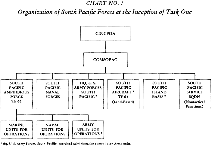
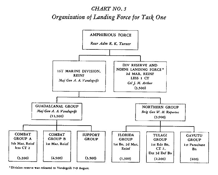